The map projection The needs of navigation, and in parallel, geopolitical strategies that encourage, soon found answer in achieving maps. Humboldt, who give a big boost to geographical science straddling the eighteenth and XIX summarized the relationship between exploration and strategy: "You only find what you are looking for." Nor should we exaggerate the importance of this conceptual approach, because many of the "discoveries" (geographical or technical) were findings at all expected or imagined. However, geography was created by a default sociomentales needs that drive to develop an entire technical system of projection that is able to draw "a distance" the ways of the world, illuminated in one blow. That projection is not nothing but a more important tool: the prediction.
This is the reconstruction of the alleged letter Toscanelli (1474).

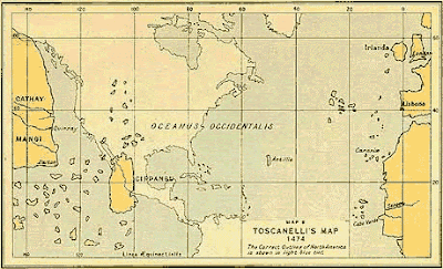
The Genoese Paolo Toscanelli nautical chart would have done this in which revealed that the coasts of Asia were close to Europe, assuming that between Zipangu (Japan) and the Canary Islands is 3,000 nautical miles, there are actually 10,600 miles -. Columbus would have used this map in his first Atlantic crossing. However, no evidence of their existence. Columbus probably invented the document to have better geographical excuses to employers, but was aware of the ideas of the Italian. Bartolomé de las Casas also refers to this letter but never saw her personally.
In any case, What is interesting in this story is the urgent need sleight of Columbus and the political, business and scientists of the time of obtaining a prediction system "that hold", from which justify the exploration, on which discussion and plan, on which see their own logic. The culture of modeling interface is also in the mapping. Toscanelli pioneered the use of meridians and parallels to fix the road distance.

modern interpretations of the alleged letter Toscanelli.


 medicine Scene (Florentine Codex, Book 11)

